Geocache map
This is a translation of Cachekarte. Please insert only links to (existing or to-be-written) English language Wiki pages here. In diesem Artikel bitte nur Links auf englischsprachige Seiten verwenden.

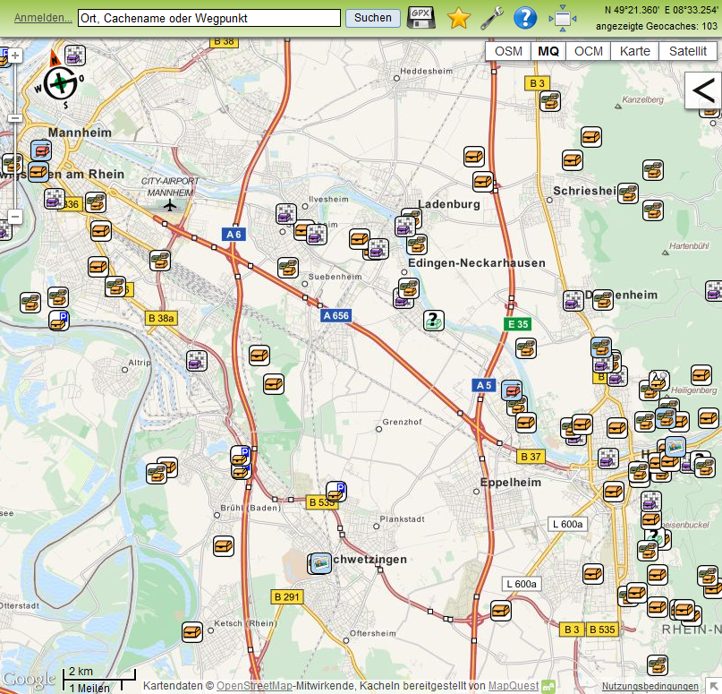
The Opencaching map is an alternative to the search form to search for interesting geocaches at Opencaching.de. The default view shows all active geocaches (status: available) within the map section except your ignored caches.
Selecting a destination area
The map section can be moved per drag and drop or with the arrow keys of your keyboard. You can zoom in and out either with your mouse wheel, by using the plus/minus buttons in the map's lower-right corner or the plus/minus keys of your keyboard. You can directly zoom into a specific map section by pressing the shift key and click & mark the area with your mouse.
To search for a location you can enter the town, parts of the cache name or waypoint name into the search field on top of the page and click Search. A drop-down menu opens showing you matching search results. Click on the correct search result to open the map area or modify your search.

Display the geocache
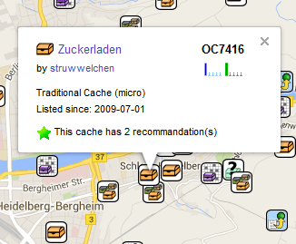
Click on the geocache symbol to display a small overlay window with basic information to the cache. Click on the geocache name to open the geocache's listing.
If the geocache has additional waypoints then they show up on the map after clicking on the geocache symbol. They remain visible until you click on another symbol. You can click on the waypoint symbols to get more information.
If the geocache listing has a preview picture then the picture will be displayed on the map. Owner can define preview pictures to be displayed on the map.

Narrow you search results
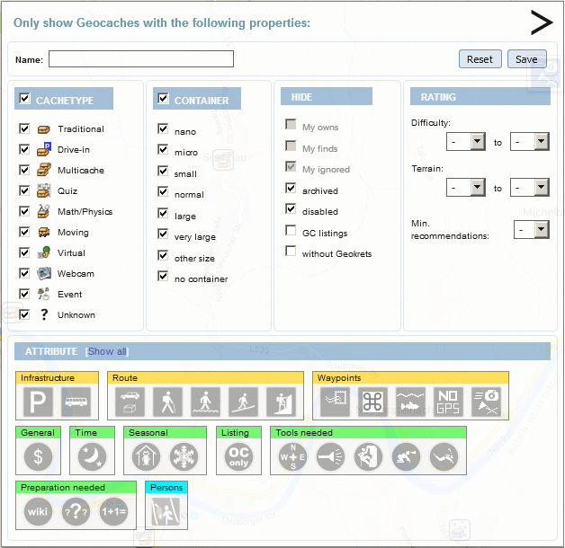
In the upper right corner of the Opencaching map you can see a black arrow symbol. Click on the symbol to open filter options. You can narrow the displayed geocache results by enabling or disabling the filter options. You can select cache types, container sizes, status, ratings and attributes. After changing the options the map displays only geocaches according to your selections. You can also filter for parts of the geocache name, e.g. "night" or "forrest".
Hint: The filter option page has a delay of 2 seconds to prevent reloading the map within normal mouse click intervals when you change several options. You can omit the delay by clicking somewhere on the map just after changing the options. This action immediately accepts the changes and reloads the map.
You filter selections stay enabled until you manually reset them by clicking on the Reset button or by closing your browser window. You can save your filter options by clicking on the Save button. Saving your selections causes the map loading your settings after opening the Opencaching map in your browser or clicking the Reset button. By saving your define your new default view.
Map functions
Next to the search field you can find following additional functions:
| goes to your home coordinates. You need to be logged in to use this function and you need to save your home coordinates into your user profile. | |
| downloads all currently displayed geocache data as compressed GPX file. This function is only available for a maximum of 500 geocaches at a time. | |
| creates a link to the current map section. You can copy the link and use it in e-mails, posts or just save it as a bookmark. If you use Firefox or Internet Explorer you can save the link directly to your bookmarks. | |
| opens a Settings overlay window where you can define some basic setting for the Opencaching map. You must be logged in to change your map settings. | |
| switches from full screen map to a smaller map display. The smaller map display is embedded into the normal website layout. You have access to the navigation bar on top of the page. The filter options are displayed below the map. The left menu bar offers map short cuts to jump directly to the federal capitals of Germany. | |
| switches from small map display to full screen. |
Map types
You can choose between several map providers in the upper right area of the page:
- OSM
Map data from the free OpenStreetMap project. The data is often more up-to-date then commercial map data and contains additional information.
- MapQuest (MQ)
Map data from the free OpenStreetMap project but preprocessed in a different way. The data is more clearly represented and shows details in higher zoom levels only.
- OpenCycleMap (OCM)
Map data from an open and free project, that processes OpenStreetMap data for bicycles.
- Map
The Google street map, optionally with terrain view. Google maps are very exact and show points of interest.
- Satellit
The Google satellite map, optionally with labels for streets and towns.
Display waypoints of a geocache
Waypoints of a geocache are sometimes hard to find on a map full of geocaches. But there is a work-around for that:
- Open the geocache listing,
- click on the link Opencaching.de below the small map,
- open the filter options menu and hide all geocaches by disabling the checkbox next to Cachetype,
- close the filter options menu and reload your browser.
Now the map in the geocache listing displays this one geocache and its waypoints only.
Leave full screen map
There are several ways to leave the full screen map and return to the normal Opencaching website layout:
- Click on the Opencaching logo upper left on the page to go to the home page,
- click on the user name (if you are logged in) to go to your user profile,
- click on the geocache name in the displayed small overlay window of the cache to go to the geocache listing,
- click on the
 symbol to switch to the small map display.